Pete's Trip Reports

Pete's Trip Reports
While doing the Snowdonia Way, I came across some signposts for something called the Snowdonia Slate Trail, which sounded interesting, and definitely worth a further look. I ordered the guidebook as soon as I got back, and we eventually got it planned in for the start of September 2019.
It was a bit of a hike getting to Bangor on the train, but we made it there for the middle of the afternoon, and got checked into a B&B. The start of the trail is just outside town, at Port Penrhyn, so we headed off to work out the best way to the start, to ensure a slick getaway in the morning. On the way back we were surprised to come across a vegan restaurant, so stopped off for our evening meal, which turned out to be excellent.
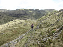
We were down at breakfast with fully packed rucksacs for half past seven sharp, to take full advantage of the buffet breakfast. The dining room had large windows, with superb panoramic views across the Menai Straits to Anglesey. After breakfast, we walked over to the start at Port Penrhyn, so we were on the move on the actual route at half past eight. It started off along easy cycle path through trees, fairly quiet, the occasional runner or dog walker, and a nice morning, dry with quite a bit of blue sky, and patches of sunshine that came and went. More easy walking on minor roads and field edges, and as we gained a bit of height, there were good views back towards the coast to Penrhyn Castle, and even across to Anglesey. A nice bit of oak forest took us to Halfway Bridge, where we made a slight navigational hiccup, by overshooting the footpath turnoff and walking alongside the A5 for too long. It took us a little while before we realised, but we eventually double backed and picked up the path.
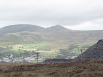
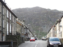
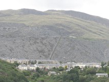
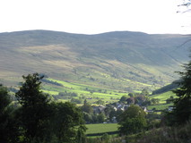
Various grassy tracks, sometimes through little clumps of trees, took us towards the small church at Llanllechid, where we walked through the churchyard, and out the front gate through an impressive tunnel formed by yew trees. Views of the massive Penrhyn quarry started to appear across the valley. Eventually the route dropped down to Bethesda High Street, and popped out right beside the community cafe, where we headed in for a pot of tea and toasted teacake. As we left Bethesda, we passed lots of large slate tips, which seemed to go on for ages. Eventually we made it to the moorland of Gwaun Gynfi, which was a nice stretch through heather, with great views back to the hills overlooking Bethesda, and even some views out to Anglesey in places.
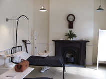
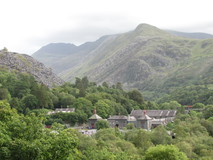
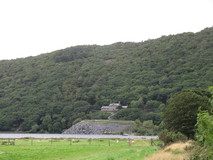
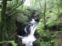
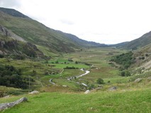
After some minor roads and small tracks, views of Llyn Padarn started to appear, and then Llanberis itself. We entered Padarn country park, which was superb walking, descending through gnarly oak trees and heather-covered hillside. Part way down the route passed by the entrance to the old hospital for the slate quarry, which was built in 1860, and dealt with the various accidents and ailments that used to befall the quarry workers, and is now a museum. We went in for a quick look round, very interesting, well worth a visit. Some of the medical equipment looks a bit gruesome by today's standards, but apparently the hospital was quite state of the art at the time. We pushed on down the hill, past an old 'slate incline', where the slate blocks were lowered down steep rails on trolleys.
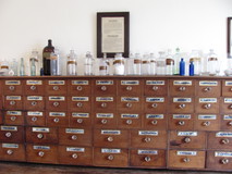
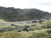
At the bottom of the hill we came to the slate museum. Another interesting place, located in the buildings of the old quarry workshops, containing all the services they needed to keep the quarry going - lots of different workshops, complete with power from a huge waterwheel, a forge, miners canteen, and even a row of quarrymen's houses. From the museum it was only a short walk to Llanberis, and the YHA was slightly outside of the town, so we pushed straight on up the narrow road to reach it at about half past five. We hired a towel, and had quick showers, so we could get our towel deposit back before the warden left for the evening! We headed back down into town for tea, and went to the small supermarket to stock up on snacks for the next day. By the time we walked back up to the YHA it was almost dark, and we got overtaken by lots of bats darting about..
Today was a slightly longer day, so we got going at seven o'clock sharp. The route climbed away from Llanberis on a narrow road, which eventually turned into a grass track. It was dry, but there was a very chilly wind, and we had to stop at a gate to put fleece tops, waterproof tops, and fleece hats on. There were views back across the valley to the huge quarries overlooking Llanberis. As the track topped out, we passed between some old slate tips and what was marked on the map as a large forest, but all the trees had been cut down, and colourful hillside with purple heather and yellow gorse. The track turned back into a minor road again and we started descending. A strange flock of birds appeared, and flitted around en masse in front of us, keeping just ahead of us. Along here were some great views of Caernarfon and Anglesey, and we could even see further down the coast to the distinctive spiky outline of Yr Eifl that I recognised from the Wales Coast Path.
We reached Waunfawr just before nine, which was perfect timing for a late breakfast. It took a bit of looking about, but we eventually found the cafe, and we got a pot of tea and some beans on toast, while a young chap on the next table enthusiastically asked us lots of questions about the walking, and inspected my walking poles. From Waunfawr the route climbed through thick bracken that was taller than us in places, and small stretches of forest, before reaching some dry stone wall enclosures, and remains of long abandoned buildings. Then a superb stretch across moorland, with great views of the bulk of Mynnyd Mawr straight ahead of us, and Nantle Ridge to our right. Shortly after a right turn at a huge isolated boulder we sat on a rock and had a snack. The path went through some slate workings, with some large cranes and conveyor belts, and neatly graded piles of slate chips. Nearing Y Fron we skirted alongside a large flooded quarry, and lots of walls made of vertical slate slats. In the middle of the village the old school had been converted into a rather new looking community centre with attached cafe and bunkhouse, and we went in and got a pot of tea and vegetable soup. The cafe had large windows with rather impressive views of Nantlle Ridge.
Leaving the cafe, the path took to an old raised tramway, before descending through fern-covered hillside to the Nantlle quarries. This was a cracking stretch, the path picked its way through old spoil tips, remains of ruined buildings, occasional bits of rusting machinery, everything slightly overgrown, before arriving at the small hamlet of Nantlle, and the B-road that led up the Nantlle valley. Easy track took us round the back of Llyn Nantlle Uchaf, and along the valley, to rejoin the road at Drws-y-Coed. The road was closed off for roadworks, and a chap sitting in a van was stopping cars going through, so it was nice and quiet for walking. We followed the road for a little while, then turned off through a farm, accompanied by loud barking dogs. Grassy track led across the hillside, passing by the small rocky hill of Clogwynygarreg. Looking back along the Nantlle valley, it looked incredibly green, almost as if someone had tampered with the colours in photoshop. We skirted round a large area of reeds, which was an old drained reservoir.
At Beddgelert forest, there was a slightly muddy descent, then easy going through conifer forest to get to Rhyd-Ddu for half past four. A cup of tea wouldn't have gone amiss, but unfortunately we were too late for the cafe, so we pushed on, past the car park for the steam train and the Snowdon path. We still had another five miles to Beddgelert, but thankfully it was easy tourist path all the way, so we breezed along at a good rate, with nice views of the evening sun across Llyn y Gader, and we could even see the steam train chuffing its way along in the background. We finally reached Beddgelert about seven o'clock, and after checking in at the B&B, we adjourned to the rather popular pizza restaurant across the road for tea.
The B&B had a DIY breakfast setup, where they left you to your own devices in the well-stocked kitchen. It worked well, although we were a bit lax in getting going and were finally on the move just after half past eight. It was overcast, but dry, and according to the forecast there was going to be a couple of hours of rain in the morning, but then dry for the rest of the day. We made the short detour to see Beddgelert's grave, then headed along the river of Afon Glaslyn, passing a chap walking along in bare feet. A lovely section, through steep sided gorge, water crashing through the rocks and large boulders, and the path gets rockier the further down you go.
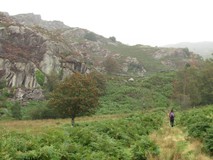
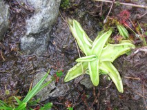
After leaving the river we passed through the small hamlet of Nantmor, and followed a quiet road to Bwlychgwernog, from where the old drove road headed across to Croesor. Just as we started along the drove road it started to rain, almost exactly as predicted by the forecast. It was along here that I had first spotted the Slate Trail signposts back in 2018, while I was doing the Snowdonia Way. The drove road goes through some superb scenery, lots of fern covered hillside, little crags all over the place, little streams, and we even found some carnivorous bog plants! At Croesor there was a small cafe and art gallery, and a break from the rain and cup of tea would have been very welcome. but unfortunately it didn't open until midday, so we pushed on.
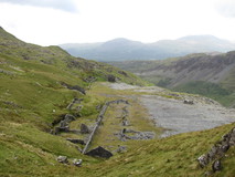
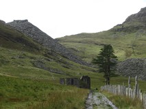
The route climbed an old mining track out of Croesor, which seemed to go on for ages, although it was easy going, wide track with an easy gradient, and there were good views across to Cnicht on the other side of the Croesor Valley. About half way up the track, the rain stopped, just as predicted by the forecast, so we were able to take off our waterproofs. The track eventually turned a corner and there were the old workings of Croesor mine, with a large spoil tip, remains of old abandoned buildings, and we could even look into the mouth of the tunnel leading into the hillside. Shortly after the abandoned workings we reached the high point for the day, then headed across the Moelwyn plateau, across an old dam, then traversing quite lumpy landscape. There were superb views all round, and an interesting lighting effect as patches of sunshine quickly blew in and out. The massive spoil tip of Rhosydd mine came into view, shortly followed by the ruins of the mine buildings. The old mine buildings are quite an eerie sight, what looks like the remains of an abandoned small village, in the middle of nowhere, halfway up a mountain!
We had a look down the old mine tunnel, and then sat down for a snack behind one of the ruined walls, to escape the chilly wind. The temperature changed from minute to minute, one moment it felt quite warm in the sun, then a few minutes later it was dull and cold again. From the old mine buildings we descended past more slate tips, and a good track took us past the small lake of Llyn Cwmorthin, the remains of an abandoned chapel, and even more slate tips, to arrive at Tanygrisiau. There was a cafe overlooking the Tanygrisiau Reservoir, and we stopped for a pot of tea, and beans on toast. Leaving the village, we passed through some sort of car scrapyard, then headed off into thick ferns to arrive at a hilltop overlooking Blaenau Ffestiniog. We dropped down into a terraced street, and quickly came across a supermarket, where we stocked up on ginger snaps and barra brith for snacks.
The town has a rather impressive backdrop, looking down most streets there are either huge towering cliffs, or massive slate tips that dwarf the houses below. After passing some large sculptures made of slate the route left town, and we got a bit confused with the instructions, but eventually found ourselves descending a path through a pleasant oak forest. Easy track walking took us along the valley towards Llan Ffestiniog, although part way along we did have a bit more navigational confusion, and it took us a while to work out the proper route. Nearing Llan Ffestiniog there was a lovely stretch through the Afon Teigl gorge, as the path picked its way along the sides of the gorge, a bit airy in places, and often knee deep in bilberies or heather. We finally made it to Llan Ffestiniog just after seven, where we had booked in to the pub in the centre of the village. The pub originally closed down in 2009, but got taken over by the community, and they have been gradually refurbishing and improving it, a rather impressive effort. It looked a bit weather beaten on the outside, but was good inside, very welcoming, and we got booked in and had veggy curry for tea.
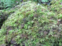
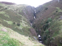
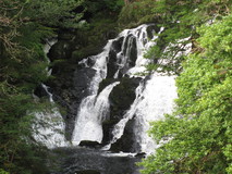
The pub breakfasts normally started at eight, but they were happy to do a half seven start for us, and a few other guests seemed to be doing the same thing when we got down to the dining room. We were on the move again just before eight, and dropped down to Cwm Cynfal, which was a superb section, a steep sided gorge full of waterfalls, cliffs, and thick moss covering everything. After passing Cwm Farm, views appeared of the impressive large waterfall of Rhaeadr y Cwm, and the route climbed up the hillside to one side of it, then crossed over a road to enter an area that the book described as 'extensive dry heathland and blanket bogs'. We certainly found the blanket bogs, but I don't think we found anything that could be described as dry heathland. As we floundered through some tall ferns next to an abandoned farmhouse, we came across two chaps who were also doing the Slate Trail.
We now joined the route of Sarn Helen, an old roman road, which we hoped would mean a slightly more solid track, but the marshy ground continued, and in places we slowly picked our way across rocky hillside to avoid sloshing about in the bog below. Eventually we left the roman road route and dropped steeply down into the valley of Cwm Teigl to join a narrow road. After the marsh it was quite pleasant to be on something solid, and we followed the road as it climbed up to the entrance to the Manod Slate quarries. The sun even came out, and the valley was a bit of a sun trap, so it was quite warm climbing up the steep road. At the top of the road, we joined some tracks which took us to the remains of the Rhiw-bach quarry. The approach was rather impressive, after nearing the quarry on a flat track, the path turned and dropped down the old quarry incline itself, to reach the ruins of the old quarry buildings, and we had a look around before pushing on.
Forest tracks took us to the slate tips overlooking Cwm Penmachno, and the track snaked its way down through the tips, and past various ruined buildings to reach the road. As we walked through the village, two people in their garden cheerfully pointed us to the turnoff, which climbed through fields to reach a forestry track above the village. Looking back there were superb views back to the slate tips, which completely dwarfed the tiny houses below. We were expecting to breeze along this stretch without much effort, but the track climbed for quite a while, which was hot going in the late afternoon sun. Eventually we dropped down to Penmachno, where we were enticed into the pub by a chap standing outside having a cigarette, and we got a pot of tea.
It was about five o'clock when we left the pub, and we still had quite a bit to go. More forest trails took us to Roman Bridge, where there was a short walk along the B4406 to get to Conwy Falls Cafe. The road section was a bit grim, not much verge to speak of, but thankfully the traffic wasn't too heavy this late in the day. From the cafe we left the road and took a short bit of permissive path through pleasant forest, which avoided the A-road, then easy track and a minor road got us to Betws y Coed. The B&B was a bit outside of the village, on the far side, and we eventually arrived at seven. After dropping our stuff off we walked back into the village, as it was Saturday night everything was quite busy, so we got some stuff for a picnic instead from the small shop and bakery.
Breakfast was at eight o'clock, so by the time we got going and walked back into town and crossed the bridge over the Afon Llugwy it was quarter to nine. It started off with easy walking alongside the river, there was even a raised boardwalk to get over some damp bits. At the Miners bridge we turned and climbed steeply away from the river, passing a sign for a high level route for when the river was in spate. Near Swallow Falls, the path traversed steep hillside that dropping away to the river, and there were good views of the falls. We eventually popped out at the A5, next to the Ugly House, which didn't look too bad to us, then climbed a very steep minor road, followed by easier forest track. As the forest opened out a bit there were some great views ahead to Moel Siabod, then easy path through fern covered hillside to descend to Capel Curig.
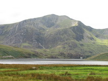
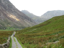
There wasn't a lot at Capel Curig, but the outdoor shop had a vending machine, so we got a couple of cups of tea and adjourned to the benches outside the shop to watch the comings and goings, and finished off the grapes that we had left over from last nights picnic. From behind the outdoor shop, an easy track headed off along the valley, and we made quick progress, with increasingly impressive side-on views of Tryfan. As we neared Llyn Ogwen, we crossed over the A5, and went round the back of the lake. It was rougher ground, over rocky bits, and a few marshy bits with stepping stones, which slowed us down quite a bit. As it was a Sunday, there were lots of people out, and looking across to the other side of the lake we could see bumper to bumper cars and vans parked up in the lay-bys alongside the A5. As we neared the end of the lake, there was a boulderfield that required some clambering, to reach the A5 again at Idwal Cottage.
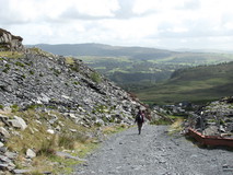
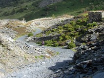
Idwal Cottage was quite a popular spot, there was a small serving hatch, lots of people sitting about on benches in front of it, and walkers and climbers arriving all the time. We got a couple of cups of rather stewed tea and some crisps from the hatch, and sat in the sun for a while. From here the route took a quiet back road down the impressive wide valley of Nant Ffrancon, only a handful of cars, and a few groups of cyclists went past. As the road turned right to rejoin the A5, we continued on gravel track, with views of the Penrhyn slate tips straight ahead of us. I had done this bit before, on Day 6 of the Snowdonia Way, but it went on for a lot longer than I remembered, the slate tips just keep on going! Part way along we spotted some strange movement out of the corner of our eyes, which turned out to be people flying past on a zip wire that they have built in part of the quarry. We reached Bethesda main street, which was the official end of the Slate Trail, at five o'clock. With uncanny timing, the second we arrived at the bus stop, before we even had a chance to look at the timetable, the bus to Bangor arrived and we jumped on.
So the Slate Trail turned out to be an excellent route. As promised by the name, it passes by plenty of old slate workings - old mineshafts, massive spoil tips, built-up levels and inclines, abandoned buildings, overgrown ruins, and rusting machinery. Often they are on a grand scale, and in the most improbable of places. And linked by a good mix of heathery moorland, grassy tracks, old drove roads, small country lanes, riverside paths, forestry tracks, and the odd marshy bit. Interesting to see some of the more out of the way parts of Snowdonia too, rather than the usual haunts. Hard to pick out favourite bits, but the traverse from Croesor to Tanygrisiau on Day 3 was a superb stretch, passing through the rugged hillside of the Moelwyns, and the spectacular and slightly eerie remains of Rhosydd Quarry. Also, the superb waterfalls, cliffs, and moss covered ground of the gorge along the Afon Cynfal on Day 4.
Here are the stats for the route:
The waymarking is mostly fairly good, but there are the occasional bits where it peters out. The book instructions are fine most of the time, apart from the odd ones which left us a bit puzzled. The maps in the book are rather vague, you definitely couldn't navigate using them, so worth getting hold of the OS Explorer maps, especially for the higher up more remote sections. Overall, highly recommended if you are looking for a good walk in North Wales that is a bit off the beaten track, with some interesting and spectacular sights.