GR58, Tour du Queyras - July 2010
Two week trip, following (mostly) the Tour of the Queyras guide produced by Cicerone. The book takes in quite a bit more than just the basic GR58 route, it adds in some of the GR58 variants (particularly the superb section taking in Refuge Visto), a couple of days of the GR541 (to get to and from the GR58 from Montdauphin-Guillestre train station), some non-GR58 variants of better quality than the standard route (like the Grand Canal route from Saint-Véran), and lots of suggestions for optional peaks along the way.
Day 1: Montdauphin to Refuge de Furfande (via GR541)
- Warm sunny day, blues skies, some thunder later in the mountains
- Not much in the way of facilities in the vicinity of Montdauphin-Guillestre train station, but we managed to stock up with a few sandwiches and pastries from a small nearby pattiserie that opened at 6am
- Got going at 8:30am, it was already quite warm as we climbed up the road hairpins towards Le Coin
- At Le Coin we joined the GR541, starting off on forest track, and then after Cabane du Bois Durat to steeper singletrack, shaded by trees. Good views of some spiky sandy pinnacles high up on the hillside
- Col Moussière was hidden from view at first, but then appeared after the route reached a shoulder
- A rocky descent through some patches of snow to Lac Lauzet, where we stopped for a snack
- Rumbles of thunder and lightning flashes in the distance as we climbed up to Col Saint-Antoine
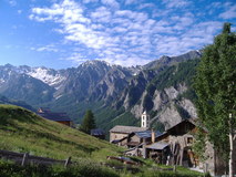
- Finally, descent down to Furfande, and picking our way through the various chalets scattered about the hillside to reach Refuge de Furfande
- Quite a busy dortoir, lots of snoring!
Day 2: Refuge de Furfande to Ceillac (GR 58)
- Hot sunny day, blue skies
- Got a good early start from Refuge de Furfande, already on the move at 7:30am, now on the GR58 proper, gently descending traverse across the grassy hillside in the shade, and then steeper rocky zig-zags
- After reaching Les Escoyères the route descended down seemingly endless road hairpins to the valley bottom. From there it was a hot climb up dusty track to the small hamlet of Bramousse, where we sat in the pleasant shady garden terrace at the refuge and had a snack
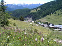
- Climbing through grassy meadows, lots of flowers, to the the old church and small handful of chalets at Chalets de Bramousse
- Cooler section through trees up to the col, where there was a nice grassy area to sit, and cracking views appeared of mountains on the other side of the valley
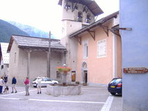
- Very steep tight zig-zags on narrow path descending to Ceillac. The top part of the town wasn't much to speak of, but the older lower part had some nice old buildings. Got stocked up at the small supermarket. Also a few sports shops in town, one of which had a good stock of the all-important screw top camping gaz cannisters needed for my MSR stove
- We were 2 days too early for the nearest campsite (Moulet), which wasn't open until July, so has to push on a bit further out of town to Melezes, nice site by river, made pasta and tomato sauce for tea
Day 3: Ceillac to Saint-Véran (GR58)
- Warm sunny day, blue skies
- On the way back through the village, stocked up with Gateau du randonneur, Pain de raisins, and vegetable pasties from the excellent patisserie. A huge gaggle of walkers went past just as we were coming out of the patisserie, but thankfully soon took the GR5 turnoff towards Col Fromage
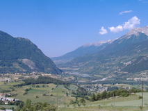
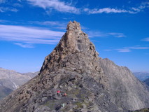
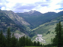
- At Col des Estronques (2651m) interesting views of Saint-Véran appeared, widely spread on the hillside far below. Quickly popped up Tête de Jacquette to get some good views of the more distant mountains
- Rocky at first coming down, but then nice winding path through trees, with a springy layer of pine needles. Nearer to the bottom grassy meadows thick with flowers
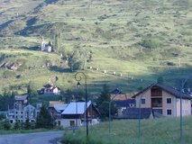
- Interesting town, very atmospheric, old wooden houses and barns, narrow main street. Very small grocery store compared to Ceilac, but reasonable amount of stuff for its size, and with a bit of searching we managed to stock up with 4 days worth of day snacks and evening meals
- Got beds at the refuge at the far end of the village, very quiet, had a room all to ourselves
Day 4: Saint-Véran to Refuge Agnel (Grand Canal route, then GR58)
- Sunny day at first, more cloudy later
- Patisserie opened at 8am, so nipped down to stock up on breakfast items for the next couple of days
- The official GR58 route dropped back down to the valley bottom for a while, but the cicerone guide recommended a newer and better route, the 'Grand Canal Route' which contoured the hillside high above Saint-Véran, and turned out to be absolutely superb
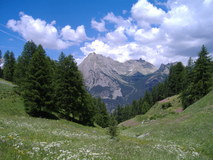
- At Chapelle de Clausis we met up again with the official GR58 route and climbed up to Col de Saint-Véran, with great views of the imposing Tête de Toilles
- Clouds started rolling in from the Italian side of the Col, so we pushed on up to Pic de Caramantran (3025m), where the visibility wan't that good, so we didn't hang around and descended down to Col de Chamoussière
- From the col there was a long descending traverse through snow to get down to Refuge Agnel. Inbetween the patches of snow were a mixture of crumbly wet schist and mud. Some entertainment just before the refuge as we came across two marmots having a fun-fight, completely oblivious to our presence
Day 5: Refuge Agnel to Refuge Viso (GR58D)
- Sunny day, rain and thunderstorms later on
- Easy walk up to Col Agnel where there was a good view back down the winding hairpins of the road to the refuge, and the route crossed over into Italy
- Descent down the Italian side managed to avoid the road, cutting off hairpins, and then following a stream. At the bottom where it met up with the road again, there was a new stretch which cut off a bit of road walking via a short steep stretch, past a mini-crag with bolted routes on it
- We pushed on up the Soustra valley, past some small stone farm huts at Granges Bernard. Two large dogs were hanging about, but didn't seem particularly interested in us as we went past
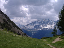
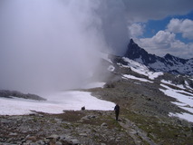
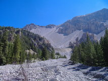
- At the head of the Soustra valley, the route steepened up to climb up to Passo della Losetta, and there was a long climb up a snow slope. By the top the cloud had come in and it was raining, so took a compass bearing to get off in the right direction
- The traverse between Losetta and Col Valante goes right under the face of Monte Viso. Near to the start there was a slightly dodgy bit where the track was falling away and there was a steep drop off below. The rain had got heavier, and there were rather ominous rumbles of thunder that seemed to be getting closer. After a bit of searching we found a large overhang to shelter under while the rain passed by
- We pushed on to Col Valante, where the roure crossed back into France. The col had even more snow that Passo della Losetta, it stretched almost all the way back down to the valley. We carefully picked our way across the snow slope, until we reached a large finger of steep loose wet schist, where we slowly descended. It took a long time to get back down to the valley, it was about 6pm by the time we got down. Surprisingly, a bunch of 5 people passed us who were just heading up towards the Col. As a final challenge the stream was running quite deep so we had to paddle across in bare feet
- Quite a relief to be down in the valley, and a short climb got us up to virtually deserted Refuge Viso. It had turned into quite a nice evening, there were great views back to the Col and to Monte Viso, and while we cooked up some pasta outside the refuge we were able to pick out the 5 small figures slowly traversing across the snow to the Col
Day 6: Refuge Viso to La Monta (Some GR58D then following Torrent le Guil)
- Nice morning, blue skies and sunshine again
- We climbed up towards Col Selliere, where the route again crossed over from France into Italy. There was a great moment near the top where a family of bouqetin trooped past silhouetted on the skyline. From the top there were superb views down the Italian side, which was very deep in snow. Another person turned up, spent some time putting some crampons on, and then picked his way very slowly down the steep snow slope
- After yesterdays exertions in the snow, we though better of it, and backtracked down the way we had come up to take the route along the valley bottom, following the Torrent le Guil. It wasn't quite as exciting as the high cols, but on the plus side had some superb flowery meadows, and was thick with butterflies
- At La Monta there was a nice campsite, fairly low key but friendly, spread over a wide area beside the river, just a little way down the road from the gite
Day 7: La Monta to Abriès
- Nice morning, more blue skies and sunshine
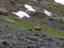
- After a bit of climbing we could see a flock of sheep up to our right on the hillside. As we got nearer, suddenly a white fluffy sheepdog appeared on our left, let out a small bark, and then watched over us as we passed by, before going back over to the sheep
- We reached the long shoulder of Crete de Peyra Plata where there were cracking views as we traversed along towards the Col de Gilly
- After the Col, the route traversed through forest, before dropping down to a stiflingly hot Abriès
- Well provisioned campsite just 5 minutes from the town, we were even able to stick all our sweaty stuff in a washing machine and then dry it out in the sun
- As it was a sunday, we were a bit worried about whether we would be able to stock up with food for the next 4 days, but there was a small shop that was open, and it turned out to be amazingly densely packed with stuff
- A decent selection of restaurants too, so for a change from pasta with instant soup mix cooked on the camping stove we went out for dinner
Day 8: Abriès to Les Fonts de Cervières (GR58)
- Reasonably early start, we were on the move by 8am. Climbed past the stations of the cross leading up to the old church on the hillside
- Further up were some old stone buildings that were being restored, there were a few blokes standing round a cement mixer, and various piles of very old timber that had been reclaimed
- Lots of people at Lac du Grand Laus, and just as we were arriving a part of about 20 Italians were just leaving. Good view of Col du Malrif high above, with a narrow band of snow guarding the top
- After a quick detour up to Pic du Malrif we started down on the steep crumbly schist and rubble. This then turned into a very pleasant meadow, beside a stream, with lots of flowers. One particular section was thick with small butterflies
- Soon reached the tiny hamlet of Les Fonts de Cervières. Sat on the stone area outside the gite in the evening sun and cooked pasta for tea
Day 9: Les Fonts de Cervières to Souliers (GR58)
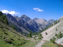
- Fairly easy ascent to Col de Péas, where we took the detour up to the top of Grand Vallon to get some cracking views of the towering rock spires of Pic de Rochebrune
- Easy descent, initially across grassy hillside, then getting rockier, then a long traverse through trees, followed by steep zig-zags doen to Souliers
- Pleasant gite, with a large terrace to sit and look at the views down the whole valley. It had 2 dortoirs, each with 32 beds, so expected a noisy night, but it turned out to be reasonably quiet and we slept very well
Day 10: Souliers to Refuge Furfande (GR58)
- The following stages from Souliers to Brunissard, and from Brunissard to Furfande looked quite short, so we decided to double up, which would then leave the last day a lot less hurried. Started off with easy climbing to Col de Tronchet. Quick detour to Lac du Souliers
- Continued descending towards Brunissard, passed lots of people, and lots of children, heading up towards the lake
- The route crossed over the road which heads up to the Col d'Izoard, and superb views of the barren rocky slopes of La Casse Deserte
- After the hordes of people heading up the path on the other side of the road, the continuing path on the other side was completely deserted. It was an excellent stretch of walking, descending down into and then along a dry river bed strewn with piles of rocks, and passing some interesting cliffs. Very hot down in the depths of the river valley
- At Brunissard we adjourned to a small restaurant and got cold drinks and sandwiches
- From Brunissard the path contoured through trees, so it was a bit cooler, mostly easy walking, although there were a couple of sections with quite loose cambered path and steep hillside below
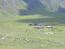
- Eventually reached the jeep track which led up to Col de Furfande and started climbing. Not too bad, the path kept away from the jeep track most of the time. At the col, a quick detour up to Pic de Vacivier to get some last views before descending down to the refuge, where we camped in the long grass nearby. Lots of school children staying, this time in tents. Two sheep dogs arrived while everyone was having their evening meal inside, and started ransacking all the tents
- Furfande gets restocked using the jeep track which climbs up to the col from the other side. We were intrigued as to how all the stuff got down from the col to the refuge, but as we sat cooking up some pasta for tea, we saw the guardienne doing repeated trips down from the col with various sacks strapped to a large rucksac frame, and often carrying a box as well
Day 11: Refuge Furfande to Guillestre (GR541)
- Final day, easy climb up to Col Garnier. On the way down from the col came across another flock of sheep being guarded by a large white dog, who came over and inspected us, then sat and watched us as we picked our way past the flock
- Interesting section dropping down into a gorge, then climbing back out on the top of a cliff
- Path soon turned to jeep track and then to road as it descended towards le Coin
- Impressive views of Gorges du Guil from the road, although unfortunately it also stood in the way of our route to Guillestre, requiring a steep descent all the way down to the river, and then a steep climb all the way back out again, in the sweltering midday heat
- Quite a relief to finally make it to Guillestre, and found a small campsite behind a hotel only a couple of minutes from the centre, where the attendant gave us a nice shady spot under a huge willow tree. After all the tiny villages and small shops, we were almost hypnotised by all the stuff in the large supermarket in Guillestre, and got a huge picnic which we ate as we lazed in the shade of the tree beside the tent