Pete's Trip Reports

Pete's Trip Reports
The JMT had been on my list of 'great walking trips to-do' for quite a while, almost a decade in fact, ever since a friend had a go at it, but the various logistical challenges and just getting enough vacation time had always conspired to keep it off the top of the list. Plus I have been deliberately spending a lot more time doing trips nearer to home of late, in the UK, and occasional wider forays into Europe. But I finally got round to having a go at it in September 2010. I arrived in San Francisco on a Saturday afternoon and spent a full day collecting together and packing all the stuff I needed (including ten days worth of food squeezed into a bear barrel), so I was literally ready to hit the trail. Day by day notes below, and assorted pictures. Apologies in advance if I have misnamed any peaks or animals!
There are fairly good transport links from San Francisco to Yosemite Valley, and I had already bought a single ticket which got me all the way through (on two buses and one train) via Merced. So I got up just before six, quietly got dressed in the dark, had a quick final check by headtorch that I hadn't left anything, and then slipped out the hostel dormitory. Just as I was going out the door, both the other guys in the dormitory wished me good luck, which was a nice touch! It was a pleasant enough walk down Market Street to the Ferry Building, in the early morning light, with only a few early commuters about, and I picked up some cookies and a large earl grey tea from a hatch enroute.
I arrived in the valley at about two in the afternoon, and walked straight over to the Wilderness Center to collect my permit for the next day. I had reserved a permit with 'Happy Isles to Illilouette' as the entry point (as the more useful 'Happy isles Pass-through' permits were long gone by the time I came to book). However, they had some unused 'Happy Isles to Little Yosemite Valley' permits available, so I was able to switch tomorrows permit for an immediate permit, and walk straight up to the LYV backpackers campground for my first night camping.
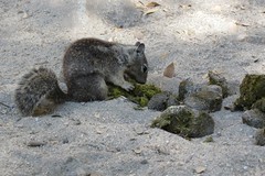
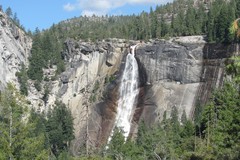
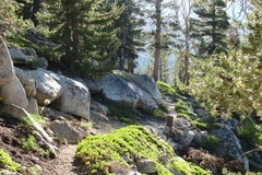
There were some scales on the outside of the Wilderness Center, so I weighed my rucsack on the way out, it came to 16.5 kg (36.4 lbs) including ten days of food in the bear barrel. I did a quick sort out, got rid of old paperwork and rubbish, and put all the loose change that was weighing me down into the donations box, then jumped on the shuttle bus to Happy Isles. There was some excitement as a small bear crossed the road ahead of the bus, immediately followed by a frenzied exodus of passengers from the bus, rushing after it with cameras in hand. At Happy Isles I had a quick packet of crisps before setting off, and it was about half past three when I got going from the official JMT start. The trail climbed quickly up a concreted path, it was quite busy, but with pleasant views back down towards the valley and not overly hot. It got a bit quieter after the Mist Trail turnoff. The superb view of the Nevada falls appeared, followed by the trail crossing the very top of the falls on a footbridge. I quickly got to Little Yosemite Valley and pitched up, then got some noodles on for tea.
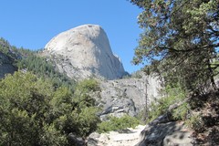
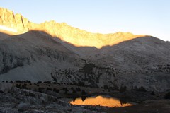
I got going about seven. There were superb views back to Half Dome, where I could see a stream of small figures climbing up the cable. I was briefly tempted by the cable route, but convinced myself that if I was going to go up Half Dome, I should come back and do it via a proper rock climb instead! Not long after the turnoff I was passed by a chap who was doing the JMT in seven days, and was heading for Upper Lyell Canyon that day, which at 30 miles a day seemed like a rather brisk pace. Nearing Sunrise, the trail changed from rocks and sand to occasional grassy areas, then into the very pleasant Long Meadow. I refilled with water at Sunrise campsite, then pushed on over Cathedral Pass. There were trail menders on both sides of the pass, busy crowbarring huge rocks out of the path. I camped at Upper Cathedral Lake, a few minutes from the lake there was an area of granite slabs with flat dusty areas inbetween them, which gave nice secluded camping spots, with perfect evening views of Cathedral Peak.
It was quite chilly in the morning, the bear barrel had a layer of frost on the top of it, and I had to warm up an energy bar in my pocket before it was soft enough to eat! As I neared Toulumne Meadows I caught a glimpse of a brown shape in the trees nearby, which turned out to be a bear ambling along, followed closely by a cub. I took the short detour through the campsite to the snack bar and shop, and had a quick snack and cup of tea, followed by a quick shave in the public toilets, and then pushed on.
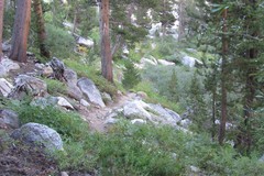
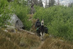
It was easy walking up Lyell Valley, following the river, relatively flat, and quite warm in the sunshine. Two young female rangers went past as I was stopped to take a photo and checked my permit. Nearer the end of the valley, the trail climbed up steep and very dusty switchbacks, and a train of horses went past, loaded with heavy looking packs and tools strapped to the outside. Further up there were a few trail menders building some rock steps. I camped at Lyell Fork, there was a nice flat area a few minutes after the bridge over the stream, and had a pan of earl grey tea, followed by chana masala for tea.
I got going at seven. The trail soon reached a pleasant lake higher up, where there was a team of 10 people from the UK just setting off. After that it was quite a rocky finish to Donohue Pass, in some places the trail went over slabs which had been thoughtfully marked out by rows of stones on either side. From Donohue the trail descended into a lovely area, grassy with lots of little tarns and streams and small pools, and clumps of interesting flowers and bushes. There was a short climb to get to Island Pass, which was quite hot, but then Island Pass was interesting, it stayed high for a while, with a series of small ups and downs. In the dips were bushes, small pools, and flowers, and there were great views of Mount Banner.
After Island Pass there was a great series of lakes, with superb views of surrounding mountains and cliffs. At Thousand Island Lake I bumped into two people that I'd previously spoken to at Lyell Fork, they had pushed on further and camped at the top of Donohue Pass, and ended up cooking in the dark. There was quite a hot climb out of Garnet Lake, then a long descent to Shadow Lake, where there were suddenly a lot more people about, most of them seemed to be heading for Ediza Lake. I fancied a short rest and snack stop at Shadow Lake, but a few mosquitos instantly appeared as soon as I stopped, so I pushed on. I pitched up at Rosalie Lake, where there was a good camping spot almost straight away on reaching the lake, and cooked up noodles for tea. There were a lot of mosquitos about, so I wore full waterproofs whilst having tea.
I got a reasonably early start, there were quite a few more good camping spots as I continued on round Rosalie Lake, and there were a few tents and super-lightweight bivis still there as I went past. I soon reached the superb basalt columns at Devils Postpile. Apparently the Postpile was once earmarked to be blown up, to make way for a dam, which seems hard to believe these days.
At Reds Meadow I got a snack in the restaurant, then had a very pleasant shower and shave, and washed some socks, in the hot thermal showers, followed by a second snack in the restaurant. The small area outside the shop and restaurant was a hive of activity, with lots of people packing and repacking their rucksacs and bear barrels. I hadn't bothered arranging any resupply packages, but instead had started off from Yosemite with ten days worth of food, with the intention of topping it up from the Reds Meadows store. However the 'hikers box' for unwanted food was virtually overflowing, including lots of really high quality stuff (Clif/Luna/Builder bars), and tons of noodles, so I was able to fully restock without having to buy anything at all! The walk from Yosemite to Reds seems to be just enough time for people to realise that they have brought too much food, which they then have to give away! With the next ten days worth of food in the bear barrel, it took about 20 minutes of extra compressing and recompressing to finally get the lid back on it, which I took as a good sign that I had squeezed every last bit of space out of it.
After all the eating, showering, food scavenging, and repacking, I didn't get going from Reds until after three. There was a section across hillside surrounded by the remains of burnt trees, then reasonably pleasant walking through forest to get to Deer Creek. I camped near three guys from LA, who I had previously bumped into briefly way back at Sunrise. There were quite a few mosquitos at Deer Creek, so again I ended up wearing waterproofs socks, overtrousers, and jacket with hood up, which provided a fairly good defence whilst I was cooking and eating tea. Although I could have sworn that they deliberately wait until you have a spoonful of food in your hand, and so can't defend yourself, before they attack!
It was a chilly morning, and there was frost over all the grass beside the stream. I got de-pitched and packed up, and had a quick chat with the guys from LA, they were heading for Squaw Lake for their next camp. There weren't any water sources for the next couple of hours, so I filled up a couple of bottles. I was on the move by about seven. The path climbed up for a little while, and then traversed along a contour line, which was excellent, easy walking and increasingly superb views across to the peaks on the other side of the valley. At one point I stopped for a couple of minutes, and a small hummingird appeared only a few centimetres from my face, then quickly darted off again.
After Purple Lake there was a small pass, which didn't even have a name, but great scenery, surrounded by granite cliffs, and huge piles of car-sized granite blocks. I sat down at Virginia Lake for a short rest, and to take in the scenery. There was a long descent to Tully Hole, down massive swooping switchbacks. It seemed like a pleasant spot, but when I stopped to refill with water a few mosquitos quickly appeared, so I soon got moving again. A bit more climbing, and I eventually reached Squaw Lake. It was an impressive setting, surrounded by steep towering white granite cliffs, the photos don't quite do it justice! There were a few people camped at Squaw Lake, but it was still early, so I pushed on a little bit further to Chief Lake where I found a lovely camping spot, and had the entire lake to myself, plus totally mosquito-free.
Chief Lake is quite high up, so it was a chilly night, and I had most of my clothes on inside my sleeping bag. It was a cold morning too, especially as everything was in the shade, but I managed to get going reasonably promptly, and was on top of Silver Pass by seven, where there were cracking views back to Chief and Squaw lakes. The trail descended past a couple more lakes, where there were a few tents pitched up, and then through forest, where there was still a lot of frost on the grass. Eventually, after quite a bit of walking in the shade I finally hit a patch of sunshine, and I sat down on a rock to soak up the warmth for a while, and have an energy bar for breakfast.
I passed by the Lake Edison turnoff, and got started on the long climb up to Bear Ridge, via what felt like hundreds of switchbacks (apparently 57 of them in reality). It was fairly easy angled though, and mostly in the shade so not overly taxing. It took me a couple of hours before it eventually levelled off, then further on there was some nice descent through birch trees to Bear Creek. Bear Creek was a pleasant spot, a slight breeze so no mosquitos, crystal clear water flowing over clean granite slabs, and little pools here and there. There were quite a lot of camping spots judging by the number of old fire rings, and I passed a few tents on the way up. I pitched up at Upper Bear Creek Meadow, not really a meadow as you would normally think of it, but granite slabs, and some dusty patches for tents. The sun went behind the hills at about six, and the wind died down, and a few mosquitos appeared, so after some noodles I adjourned to the tent fairly early.
It was another chilly night again, but I was up and away before seven, wearing waterproof overtrousers and jacket to keep warm. Selden pass was nice, a mini-canyon of white granite, with occasional shrubs and clumps of flowers, and superb views back to Marie Lake. It descended to Sallie Keyes Lakes, which was a gorgeous spot, the path went between the lakes, right on the edge of the water, and I could see fish leisurely swimming about in the crystal clear water.
There was a mammoth descent after Singer Creek, with long switchbacks down a hillside covered in small bushes, and no tree cover, which was a bit unusual, and made it hot going in the sun. Back at Reds Meadow I had packed enough food in the bear barrel to get me to Whitney Portal, but Muir Ranch was rumoured to have a well-stocked hiker box, so as it was only a short distance off-route I made the detour down, on the basis that a couple of extra energy bars a day certainly wouldn't go amiss! There was a hut there full of tubs that people had sent ahead awaiting collection, and there were two guys who had just picked up a tub and repacked their barrels, and were just about to get going. Sure enough there was plenty of unwanted food, neatly categorised into different plastic tubs. So I was able to stock up with an extra 2 energy bars per day for the remainder of the route, not quite the same high quality bars as I had found at Reds, but not to be sniffed at.
I pushed on at about two, it was hot along the valley bottom, but I soon reached the Piute Pass turnoff. The next bit was a superb piece of walking, with the path picking its way up a rocky canyon, with the San Joaquin river below, and towering cliffs above. I continued on to Franklin Meadow (another meadow consisting of rock slabs and dust patches only) which was a nice place to stop for the night. Noodles for tea again!
I got a nice early start and was on the go by quarter to seven. It was a pleasant ascent to Evolution Meadow through trees, with good views of the stream running over wide granite slabs, with lots of small waterfalls and plunge pools. Normally everybody else I ran into looked quite dusty and dishevelled by this point in the trail, but at Evolution Meadow I passed a party of very clean looking people, which was really noticeable, and seemed odd, until I noticed some horses tethered up on the grass nearby. For some reason I was feeling rather weary on this section of trail, and a bit lacking in energy. However, I bumped into a chap from Seattle, who was doing the JMT with a group and we walked together for a while. He was quite fit, had done a lot of mountaineering, and a very keen lightweight gear enthusiast, and we discussed trips and different bits of kit as we went along, which helped lift me out of my weary state.
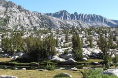
From Evolution Lake onwards, the scenery gradually got rockier and more rugged. At Wanda lake I was surprised to find lots of frogs. Everytime I got near to the waters edge I would see sudden movement out of the corner of my eye, and a plopping noise, as frogs sitting sunning themselves on the rocks jumped back into the water, then I could see them swimming about in the crystal clear water. From Wanda Lake I could see the small hut on Muir Pass, but it took quite a long time to actually reach it. The scenery was absolutely stunning on this stretch, quite a barren rocky landscape, dotted with lakes and small tarns, and surrounded by peaks, it reminded me a lot of the equally superb stretch before Col de Prafleuri on the Walkers Haute Route in Europe.
At Muir Pass I met a chap who was doing the Sierra High Route, a 314km (195 mile) route that parallels the JMT, but much of it is off-trail. He was very enthusiastic about the sections he had done so far, it sounded absolutely superb. After the pass, the excellent rocky landscape continued as the trail went past Helen Lake, then down a steep gully to another small lake, where there were some good, if rather minimal, camping spots. There were some tents already pitched up, and it didn't look like there was much space, but I wandered over and had a look, and one of the women pointed out a good free spot. I got pitched up and quickly got some food on the go. The three women already pitched up were working their way through sections of the Pacific Crest Trail. As if that wasn't enough, one of them had already done the entire PCT from Mexico to Canada in a single season, starting in April and finishing in September.
The three PCT women were very efficient at getting going, and were up and on the move by half past five. I finally got going at a comparatively sluggish seven o'clock. It was quite chilly, and wiping a layer of frost off the bear barrel and the tent left my hands quite cold as I was packing up. The trail descended from the small lake through trees, there were more camping spots further down, and all the grass was covered in a layer of frost. I bumped into two guys from Brighton who were busy brewing up a morning coffee at the side of the trail, which was very civilised. I was intrigued by some strange large footprints in the dust of the path, which didn't look like horse or bear prints. I checked up on the latest weather forecast as I passed by the ranger cabin at Leconte Canyon, apparently some cold weather coming in for a couple of days, and possibly some sprinklings of snow higher up, but not enough to accumulate.
Later on I came across two blokes with three lamas, which explained the strange footprints. The trail started up the Golden Staircase towards the Palisade Lakes. It was an impressive piece of trail routing, tight switchbacks up steep gullies, and traversing over steep headlands. However the weather took a turn for the worse. It got very cold, and there was an icy wind, and by the time I got to the top of the Golden Staircase it had started hailing. At the first Palisade Lake, people seemed to be hurriedly pitching up to get out of the cold and hailstones, and a mini tent-village had sprung up on the rather windswept area above the trail. Someone spotted me walking past and very kindly came over to say there was still some space if I wanted to pitch up there. I stopped for a quick chat, and thanked him, but it still seemed a bit early to call it a day, so I decided to push on a little to get a bit nearer to the pass. With full waterproofs on it wasn't too bad, as long as you didn't stop moving for any length of time.
By the time I had got to the far end of the second Palisade Lake, and pitched up, I was definitely getting a bit chilly though, and I jumped in my sleeping bag fully clothed for a while to warm up. By about six it hadn't got any better, and it was very tempting to stay in the tent, and not bother going outside and cooking, but eventually I roused myself into action and went out to try and find a sheltered spot. A bit of a search round found a slightly sheltered spot down the hill behind some bushes, so I quickly cooked up some noodles with some added cashew nuts for a bit of extra interest. Back at the tent it looked like it was going to be a very cold night, so I left my fleecy hat, waterproof jacket, waterproof overtrousers, and waterproof socks on inside my sleeping bag to keep warm, and also put the bottom of my sleeping bag inside my rucsack to help keep my feet warm!
When I unzipped the tent inner, I could see a layer of snow poking underneath the tent outer which was a little worrying. Fortunately it wasn't as bad it looked, there was a very thin sprinkling, but not enough to obscure the trail. However it was bitterly cold ascending Mather Pass in the shade. I had a slightly unpleasant moment on the way up, and started feeling very sick, dizzy, and sweating profusely. I sat down on the nearest boulder and put my head between my knees to try and stop myself from throwing up. After five minutes the feeling passed, and I waited for another five minutes until things had totally settled down and then got going again. I put it down to a combination of the cold, the altitude, and rushing too fast in an attempt to try and warm up. For the rest of the climb up the pass I took it a lot more sedately, and felt fine. It was still bitterly cold, and near the top my hands were too cold to use my trekking poles, so I strapped the poles on the back of my rucsack (which in itself took a lot of attempts with numb hands).
I got to the top of Mather Pass at about half past eight, and suddenly popped out into the sun, which was an absolutely glorious feeling. There was a nice little rock shelf a few metres down from the pass, and I sat down and did absolutely nothing for 15 minutes, just letting the sun warm me up, and taking in the superb view down to the Upper Basin, which was glistening from the snow in places. After I'd warmed up a bit, I treated myself to a couple of energy bars, then got going again. A couple of switchbacks down from the pass I came across a couple of trail menders who were already hard at work, even though it had only just gone half past eight.
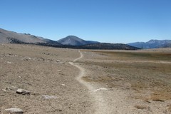
The trail soon reached the easier angled terrain of Upper Basin, where it was very easy walking, with nice views down the valley. Looking back at the pass it seemed unfeasibly steep and rocky, and it was almost impossible to work out the route of the path, apart from the two tiny dots of the path menders who were only visible if you concentrated very carefully. Climbing up to Bench Lake I bumped into a ranger who stopped for a chat, and he mentioned that that it was going to be another very cold night (although there was no more snow forecast) before warming up again for the weekend.
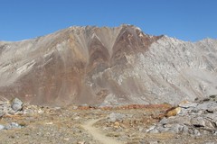
There was some great scenery at Pinchot Pass, with surrounding peaks with very distinctive coloured bands of rock running through them. There were some nice camping spots on the descent, and I passed a few people pitched up on the way down, but I pushed on for a bit longer to the camping area at Woods Creek, tempted by the fact that it would probably be a bit warmer lower down. I got there just after seven, just before it got dark. There were a few other people already pitched up, and I quickly got the tent up while boiling some water, and for tea had spicy Louisiana red beans mixed with instant noodles.
I was woken up at half six by some noise at the bear box, which sounded a bit dodgy at first, but then I heard some voices. I got de-pitched and was on the trail by ten to seven. There were good views of the huge granite lump of Fin Dome as I gradually climbed up the valley. Rae Lakes was a nice spot, the water was absolutely crystal clear, and the trail traversed right beside it, I could see all the rocks on the bottom, and large fish effortlessly gliding by. From the lake, the climb up to Glen Pass started in earnest. Initially it was switchbacks up normal hillside, but then it went into an area of huge jumbled granite blocks and rubble. Looking up towards the pass, it was hard to work out how the trail could possibly get up there through all the rubble and rocks, but it all came together as it carefully zig-zagged its way up. Some super-fast Americans with very lightweight kit breezed past at about double my speed.
There were quite a few people hanging about at the top of the pass, and great views down to the small tarn on the other side. I started down the steep crumbling hillside of dusty soil and stones, again the terrain looked a bit unfeasible, but the trail very carefully picked its way down in tight carefully constructed switchbacks. Soon Charlotte Lake came into view, a long way below, then a further descent to a sandy area with lots of path junctions. I pushed on to Vidette Meadow, where there were a few people pitched up, then found a great camping spot about half an hour further on from the unmarked Center Basin turnoff, at about 11,000 ft. It was a nice flat sandy area, not far from the path, with sweeping views back down the whole valley. I had spicy Louisiana red beans mixed with noodles again for tea. Two people went past by torchlight in the pitch blackness at quarter past eight, just as I was nicely tucked up in my sleeping bag.
I got a good early start, and was on the trail by quarter to six. It was quite chilly, and I wore my sealskin waterproof socks on my hands to keep them warm. The path stayed in the shade for most of the climb to Forester Pass, but then crossed into the sun for the last few switchbacks. I was at the top of the pass by half past eight. Superb views opened up of the rather arid landscape on the other side, and peaks in the distance. The descent down the other side was an incredible piece of trail routing, with the trail picking its way across steep rock slabs. On the way down a couple of small furry mouse-like animals popped out of the rocks as I went past. Looking back from the bottom, it looked infeasibly steep, but looking carefully it was possible to pick out the lines of the switchbacks across the rock slabs.
It was easy and fast walking down to Tyndall Creek, which was followed by an interesting mini-desert for a short while, before dropping back into trees and down to a creek, then quite a bit of upping and downing through trees to get to Crabtree Meadows. For the section of JMT in the vicinity of Mount Whitney, it is compulsory to use a 'wag bag' for going to the loo (rather than digging a hole), and there was a big tub of them at Crabtree Meadows, so I picked one up in case I needed it later on. Since I was passing, I also took advantage of the pit toilet at Crabtree. I was slightly surprised to find that it didn't have any walls round it, however the luxury of a sit down loo more than compensated for the lack of privacy!
Guitar Lake was a good camping spot, quite atmospheric, surrounded by towering granite cliffs. There was an obvious sandy area not far from the path with a few people already installed, and there was another spot a little higher up where I pitched up, then had a pan of earl grey tea, followed by my last packet of Louisiana red beans for tea.
It was another chilly night, and sometime in the middle of the night I had to put my waterproof top on to keep warm inside my sleeping bag. It was a cold morning too, but I managed to get going at about half past six. I wore my sealskin socks on my hands, which stopped them getting too cold, although made it a bit tricky to take photos. The path soon started the main climb up switchbacks to arrive at the junction off to Whitney summit, where there were already a few rucksacs deposited. After the junction there was a superb section where the trail got a bit rougher, and carefully picked its way through shattered rocky pinnacles. Occasional gaps in the rock suddenly exposed a huge vertical drop, which added some extra excitement. I reached the summit of Whitney just before ten. For a moment, the summit seemed slightly reminiscent of Ben Nevis, I think it was the crowds of people, plus the little hut on top! There were incredible views all the way down to the valley floor, and of surrounding mountains in all directions.
So technically that was now the end of the JMT, although in practice there was still the small matter of the 1871m (6,145 ft) descent down to Whitney Portal. After signing the visitor book I pushed on, back through the fantastic jagged rocky pinnacles to the junction, then a very short climb up to Trail Crest, the final pass, followed by seemingly endless switchbacks down to Trail Camp, including a short section with a layer of sheet ice on it. From Trail Camp the trail got quite interesting as it picked its way down through steep valleys and across granite slabs. Further down it turned into fairly easy dusty switchbacks through trees and bushes, before arriving at Whitney Portal. I had a couple of packets of crisps from the shop, and then wandered across to the car park where I found a lift down the 13 miles of road to Lone Pine.
I spent a night in Lone Pine, which was a pleasant little town, reasonably sized backpackers hostel, good small supermarket, climbing shop, and a few decent coffee shops, then got a very early bus to Reno the next day. I ended up being stuck in Reno for a few days, which wasn't quite the ending to the trip that I would have chosen, although I did try and make the best of it. All in all an excellent trip though, I found the JMT to be a satisfying trail, with stunning scenery, particularly the more rugged and rocky sections that are above the treeline. It is quite easy technically, and easy to navigate (you would have to try quite hard to get lost), but the need to be self-sufficient and carry quite a few days of (bear-proofed) food added extra challenge, which is quite different to most UK and European long-distance trails. I did find one serious problem with the JMT - it has now left me with a nagging urge to go back and do the Sierra High Route (the Roper Route), which looks even better still than the JMT. Now I just need to find a spare 20 days, and get fit enough to actually manage it!
..... Might add some useful tips here about permits, food, camping, transport to/from the ends ......