Pete's Trip Reports

Pete's Trip Reports
Whilst doing the Northumberland Coast Path, we had spotted St Cuthbert's Way, which overlapped with it for a short section. It looked interesting, especially as it traversed some of the foothills of the Cheviots, plus finished with a crossing to Lindisfarne. It did require some planning to get to the start at Melrose, although. getting back from Lindisfarne turned out to be easier, as my parents hadn't been to Lindisfarne for decades, and were keen to visit it, and said they would meet us there. My dad described the last time he had been there, when he had cut it a bit fine with the tides, and ended up wading back across the causeway with me (as a little kid) on his shoulders. I don't remember any of this, perhaps fortunately, but we definitely didn't want a repeat of the incident, so we took note of the safe crossing times for the days we would be there.
It was a bit of a trek to get to the start, so we split it by booking a B&B in Berwick, and two trains got us there for just after nine in the evening. We remembered the impressive town walls from the Berwick Coast Path, and we went out and did an evening tour of them, then had a quick look round town before turning in for the night.
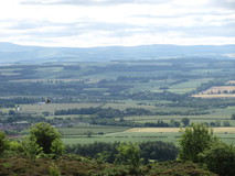
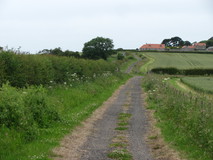
We were up bright and early, and on the first bus to Melrose, which left Berwick station at ten to seven, to finally reach Melrose at quarter past eight. Melrose was a nice little town, set against the backdrop of the Eildons, two large hills which loomed over it. We did a quick circuit of the town to find a good cafe, and had a pot of tea and some breakfast. From the cafe it was just a short distance to the Abbey, which was the official start of the route, and after taking a few shots of the Abbey, we were on the go at half past nine. The path quickly left town and headed straight up the Eildons, with cracking views back over the town, and beyond to Galashiels. The path eventually headed towards the saddle between Eildon North and Eildon Mid, passing some large bags full of stones for doing path repairs. From the saddle we descended through pleasant woodland, then a grassy meadow took us to Bowden, followed by a stretch along a small stream to Newtown St Boswells.
There didn't seem to be much at Newtown St Boswells, so we pushed on, and the route went along the banks of the River Tweed. There was some easy walking through grassy meadows, but also a few ups and downs where it climbed away from the river, on lavishly constructed flights of wooden steps, covered with chicken wire to make them non-slip. Near St Boswells the path left the river to go into the town, and there was a nice looking cafe, but unfortunately it didn't open on a Monday, so we got some picnic items from the small supermarket, and ate them sitting on a bench in the centre of town, while watching the comings and goings. After the town we rejoined the Tweed, passing by a weir where a bunch of kayakers were just launching, a red sandstone bridge, and a small well.
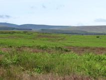
Near Maxton, we left the river, and took quiet roads to join the route of the old Roman road of Dere street. It was an interesting stretch, dead straight, taking a thin corridor between fields, sometimes through forest, in other places through grassy meadow with scattered trees. On a distant hill we could see the distinctive shape of Monteath mausoleum, followed by Baron's Folly on a later hill, and then the tall Waterloo Monument in the distance. Part of the way along was a stone that commemorated a woman called Lilliard, who had ferociously fought against the English. We finally popped out on the road near to Harestanes Visitor Centre at five o'clock. We pushed on a bit further, in the warm evening sun, crossing the River Teviot on a suspension bridge that wobbled when you walked on it, to reach Jedfoot Bridge, where we stopped for the day.
A short walk along the road verge took us to Bonjedward garage, to pick up a bus into Jedburgh, where there was a reasonable range of places to stay. Unfortunately we had just missed the bus, and didn't fancy waiting an hour for the next one, so we called a taxi instead, which arrived in about five minutes, and only took a few minutes into Jedburgh. We had a walk round town in the evening, there were some good views of the abbey in the evening sun, and then got some picnic stuff from the Coop.
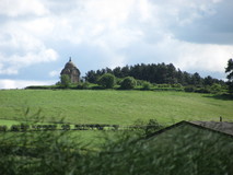
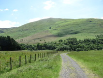
The bus back to Bonjedward was at ten past eight, so we were all packed up and at the table when breakfast started at half past seven, and we made the bus in good time. It only took a few minutes to get back to Bonjedward, and by the time we had walked back along the road to Jedfoot Bridge, it was half past eight. The path rejoined Dere Street again, but only for a short way, before turning off into some pleasant forest. At a small bridge that crossed Oxnam Water, there was a bench and a picnic table, it was a rather idyllic spot, and we sat down for a few minutes to put sun cream on. More little forest stretches and bits of farm track took us towards the small hamlet of Cessford, and there were great views of the small red sandstone castle as we approached. It was about quarter to twelve when we reached the castle, and as it was such a nice spot, we sat on the grass and had some snacks, then had a look round the outside of the castle. It was interesting how weather-beaten some of the sandstone blocks were, with deep holes worn into them.
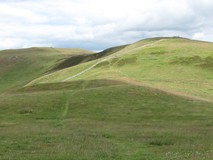
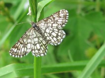
From Cessford the route took practically deserted minor roads all the way to Morebattle. At the far end of town, the pub was offering a free half to any St Cuthbert's Way walkers, but we resisted, and instead went to the community cafe in the church next door. Some chaps on vintage motorbikes were already installed on a picnic table outside, and we stopped for a cup of tea, and were slightly surprised to get served by the vicar herself. Some more quiet road walking after Morebattle took us to a bridge across Kale Water, and into the foothills of the Cheviots. We climbed up to Grubbit Law on lovely grassy path, in the afternoon sunshine, then on past Wideopen Hill, which was the highest point on teh whole path, at 368 metres. There were superb views ahead to Town Yetholm and Kirk Yetholm spread out in the valley below, and looking back back we could still see the Eildons in the distance, with the patchwork of fields in-between. On the grassy descent there were lots of orange butterflies, which taunted us by never stopping for long enough to take a photograph. The final stretch to Kirk Yetholm took us along a small stream, which some colourful patches of bright yellow and red flowers growing in it.
Today stage to Wooler looked interesting, taking in more of the Cheviot foothills, and was fairly remote, with no facilities enroute. It was a slightly shorter stage than the previous days, so we didn't have quite the same urgency to get started, and we didn't get going until nine. It was already sunny and warm, with clear blue skies. The route started out following the Pennine Way, climbing a minor road to cross a high point, then descending to a small stream, where it left the road and took to grassy path. A little further on, the Pennine Way branched off to head south, and we continued heading East. Shortly after leaving the Pennine Way, we were excited to cross over the border from Scotland into England, through a small gate in a drystone wall. After crossing a small pass, we dropped down a pleasant valley, on grass path through fern-covered hillside, to a farm at Elsdonburn, where we joined a quiet single track road along the valley towards Hethpool.
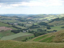
There wasn't much at Hethpool, just a handful of houses, and we left the road and crossed over College Burn to start up the hillside. It was still sunny, and quite warm as we climbed out of the valley. A short way along we came across two people sitting under a tree brewing up a pot of tea, which turned out to be a woman and her grandson who were also doing St Cuthbert's Way, and had wild camped just over the border in Scotland. The route gradually climbed up the hillside, on grassy path, surrounded by ferns and scattered gorse bushes, then skirted past Tom Tallon's Crag on fern covered hillside. We were definitely ready for a snack stop by now, and kept our eyes peeled for any shade to get out of the relentless sun, but there wasn't any to be seen, so we eventually had a short stop sitting on a rock in the sun. As we were stopped, a chap went by, and bemoaned the heat. There were some superb views from this stretch, in places we could see the great bulk of The Cheviot, and in the other direction we were now starting to get glimpses of the sea, which was very exciting.
Eventually views of the small village of Wooler appeared, a long way below. After descending from Gains Law we crossed over onto Wooler Common, and then entered a forest. Even though we were within a stone's throw of Wooler now, we were feeling a bit weary from all the heat, and we sat down for a while in the cool shade of the trees and had a clif bar to energise us for the final kilometre. An easy final descent on a small road brought us out right in the middle of the main street in Wooler. We were definitely ready for a refreshment stop, and adjourned straight to a cafe for a pot of tea, and two rounds of toasted teacakes, before heading to the B&B.
Todays section had a slight logistical challenge, in that the crossing over to Lindisfarne was tidal, and unfortunately the tides were a bit out of sync with our walk. The causeway got covered by water at three o'clock, which would require us to head off from Wooler in the middle of the night, or it became uncovered again nine o'clock, which would mean some of the crossing would need to be done by headtorch! In the end we settled for an easier option, there was a B&B with plenty of rooms a couple of km from the start of the causeway, and we rang up and booked it, which meant we could do a leisurely crossing the next morning without any time pressure. After breakfast and settling up at the B&B we got going at half past eight.
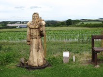
The route descended from the High Street to a main road, with a large billboard encouraging passing motorists to make use of the shops and free parking up in the middle of village. After a brief road stretch, passing the school, we joined Weetwood Moor, which was lovely walking through ferns and heather, before dropping down to Weetwood Bridge. A practically deserted minor road took us to East Horton, where we joined a farm track, to reach a road where there was an impressive sculpture, carved from the base of an old tree, of St Cuthbert himself, and an accompanying otter. Some field edges, with butterflies flitting around, took us to the edge of a forest which we followed. St Cuthert's Cave appeared suddenly through a gap in the trees. It was an impressive sight, a small sandstone crag with a large overhang, and some massive sandstone boulders lying about. It was past twelve, and a pleasant spot for a lunch stop, so we adjourned to a flat boulder at the side of the cave.
From the cave we pushed on through grassy meadows, to reach a gravel track that passed a small lake, and then went through a forest. From here all the way to the start of the Lindisfarne Causeway the route follows the Northumberland Coast Path, and we recognised most of it from our coast path walk back in 2015. There weren't any facilities in the small village of Fenwick, but we stopped on a bench for another snack. The path now crossed the busy A1, but we got across fairly quickly, followed a bit further on by crossing the East Coast Main line, where we had to phone the signalman to check it was OK to cross.
As we reached the large concrete anti-tank blocks at the start of the causeway. the tide had just started to cover the causeway. We sat on top one of the concrete blocks and watched a couple of cars cutting it a bit fine as they crossed over to the mainland, with large amounts of spray. A short distance along the causeway there was a small group of people standing where the water started, and we walked along to take a look. It was a strange sight seeing the road disappear underwater, and we all stood there slightly transfixed as the water gradually swallowed up even more of the road. We eventually managed to tear ourselves away from the hypnotic effect of the slowly rising water, and headed inland to the B&B. We started off along gravel cycle track, with signs for the "Coast and Castles" cycle route, which sounded interesting. At Beal there a cafe and campsite, and we adjourned to the cafe for a pot of tea. After tea we pushed on to the B&B, which was at the junction with the A1, although some light drizzle started up, so we had to put waterproof tops on for the last ten minutes, their only use in the whole trip!
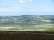
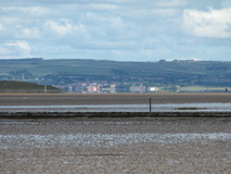
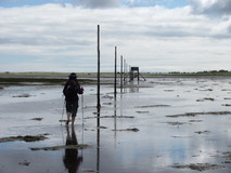
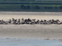
Crossing time was from nine o'clock onwards for the causeway, which meant slightly later still for crossing the pilgrims route across the sand, so we had a fairly leisurely breakfast, and got going from the B&B about quarter past nine. We walked back down the pavement, and then cycle path, to reach the causeway at ten. The route followed the causeway for a short while, to cross the narrow bridge, and arrive at the first refuge, then dropped off the causeway edge on to the sand. We took our shoes and socks off, and hung them on the back of our rucksacks, then headed off, following the line of large poles. Looking back, the causeway seemed really busy, we could see lines of cars and motorhomes heading across, so it was nice to have the peace and quiet on the pilgrims route. Out on the sand we could see what looked like a large colony of seals spread out, and looking down the coast we could see the silhouette of Bamburgh Castle. Looking inland we could even still see the great whale shaped outline of The Cheviot in the distance.
The Pilgrims Path had a few quite distinct sections. At first it was easy going on sand, which was quite quick. Then it changed to grey mud, which was slower going as it was quite slippy and the trekking poles came in useful for keeping us upright. Further on the grey mud got very soft, and our feet sank into it, with black mud oozing up through our toes. After a while the sand started again, and we made faster progress. Then there was a bit where there was some rough grass and vegetation, followed by a short stretch with lots of shells embedded in the sand, which felt a bit spikey on our feet, and slowed us down again. Finally, we reached the island, and spent a few minutes washing the sand off our feet so we could put our shoes back on. All in all the route across the sand took about ninety minutes from leaving the causeway to arriving at Lindisfarne.
From the arrival point, it was only a short distance to the village, passing a gigantic car park that was almost full, and some stalls selling Holy Island honey and fruit. We had a quick look round the village, then we adjourned to the Pilgrims Coffee shop for a pot of leaf tea and toasted teacakes. My parents arrived a little bit later, having stayed the night in Seahouses, and driven up from there. We all wandered down to the Priory, which was technically the end of St Cuthbert's Way, although disappointingly there didn't seem to be a sign marking the end of St Cuthbert's Way. So we got an easy lift back from Lindisfarne, although there is also a small shuttle bus which leaves quite regularly to go back to the junction with the A1, where there is a bus stop, and also onward to Berwick train station.
All in all a very good walk, in fact much better than we were expecting. We had expected quite a bit of farmland, but the route did well at threading its way through thin strips of trees between fields, or small forests, or keeping to field edges. The bits through the foothills of the Cheviots were excellent, they felt quite remote, and lasted most of the way from Morebattle to Wooler. And then the exciting climax of the pilgrims path across the sands, which has to be one of the best walk finishes in the UK, and well worth the slight hassle of synchronising with the tides. Here are the route stats: