GR54, Tour de l'Oisans - July 2007
Described in Walking in the Alps as 'more strenuous, more demanding, and with a much greater sense of remoteness' compared with the Tour du Mont Blanc, the Tour de l'Oisans sounded very promising indeed. We arrived in Bourg d'Oisans about 7pm after 2 separate bus journeys from Geneva. Only just in time to get a camping gas cannister from the sports shop, and some bits and pieces from a small supermarket near the bus station. Plenty of good campsites, and we plumped for the one opposite the big supermarket, as it was the nearest to the centre.
Bourg d'Oisan → Clavans le Bas
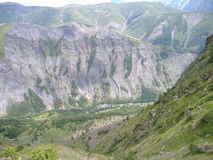
- From Bourg d'Oisans the path immediately led up steep rock slabs with wires for protection, fairly easy, no exposure
- Views of Alpe d'Huez looming high above
- After Combe Haut, less interesting bit up a wide dirt track, past a Via Ferrata signposted off up a cliff to the left
- The route crossed over a small road, then followed it up to the Col de Sarenne, accompanied by a steady stream of roadies heading up to the col
- After the col, down the road for a couple of hairpins, then turned off onto steeper rocky track zig-zagging its way down. Flowers of all colours, yellows, pinks, purples, grass alive with insects hopping about and chirping
- Stayed in a fairly new looking auberge that we spotted as we passed through Clavans le Bas
Clavans le Haut → La Grave
- Raining all night, quite heavy at times, and still raining in the morning, full waterproofs on
- Still chucking it down when we reached the small village of Besse. Everwhere was closed up, apart from the hotel, where the cheerful hostess knocked up some petit dejeuner for us
- We spun it out as long as we could, but it was still raining when we got going again about an hour later. We walked past the campsite where a rather bedraggled walker was just packing away his tent
- It gradually dried as we climbed up towards Col Bichet. By the time we reached the col the sun had appeared.
- The route crossed the Plateau de Paris, the path was surrounded by grassy plains, full of flowers, and excellent views of the northenmost mountains of the massif d'ecrins
- At the edeg of the plateau Chazelet came into view, looking down it didn't seem that far, but it turned out to be quite a long descent
- Lovely campsite at La Grave down beside the river, with a little raised section for walkers. Lovely little village, and a well stocked supermarket too
La Grave → Monetier-les-Bains
- Things started off badly as we ended up on the wrong path, walking beside the river, until we realised we should have been climbing high up onto the shoulder above the valley. We ended up scrabbling up the steep grassy slopes, under tree branches, and through swampy bits, before regaining the path.
- There was a less interesting bit crossing a silt covered flood plain along jeep tracks, before climbing steeply past waterfalls
- The path reached a small summit and flattened out a bit, past the refuge de l'Alpe de Villar-d'Arene
- Ahead we could see the glaciers and huge pile of glacial morraine at the Col d'Arsine. Marmots popping out of their burrows occasionally
- A little way after the col, we came across some shallow pools full of chubby looking tadpoles darting about
- The path went down a lovely rocky valley, winding its way through piles of boulders, surrounded by small cactus type plants with bright pink flowers. As I took some photos a passing walker stopped and told us they were called Joubarbe a toile d'araignee, and enthusiastically gave us the run down (in french) on them
- The path deposited us on a road at the edge of Monetier-les-Bains. It seemed like a bit of a ghost town, full of deserted skiing condos. It was just starting to drizzle a bit as we arrived. But the first hotel we came to had some good rooms with cooker and ensuite shower. Decent supermarket in town too
Monetier-les-Bains → Ailefroide
- From Monetier there was a pleasant walk up though conifer trees, and some big overhanging rocks
- Things went downhill a bit after the path reached some ski lifts, and the final bit up to the col was on a wide dusty jeep track under a chairlift. A Via Ferrata was signpost off to to the left
- the col itself wasn't much to write home about either, wide jeep track, a big manmade pool, and ski lifts dotted about on the hillside
- Things improved a bit on the descent down to Chambran valley though, through lots of flowery rockeries, and past some impressive cliffs, before arriving at the small Buvette at Chambran where a gang of hens inspected us while we had a cup of tea
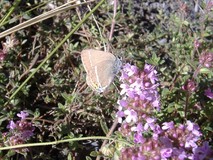
- From here the main route continued down to Vallouise, but instead we took the interesting looking diversion up to Ailefroide. This turned out to be an excellent path, quite rocky, lots of butterflies, over scree and round huge boulders of light coloured granite. Later on it went into the trees, and went past a small granite crag with some bolted routes on it, before popping out at the village. Superb situation, surrounded on 3 sides by towering grey granite slabs. Small but well stocked supermarket, and a huge campsite in a forest, we found a very comfortable and quiet spot between big boulders on a carpet of pine needles
Ailefroide → Entre-les-Aigues
- It was a clear night, and quite cold, we had to wear clothes in our sleeping bags
- We had a fairly leisurely start, there were lots of people getting ready to go climbing
- We backtracked down the track, then took the turnoff to Les Claux
- Fairly dull bit through some new condos on wide jeep track
- Last bit was better, singletrack, thick curtain of noisy hopping insects, and butterflies on the thick grasses and flowers
- Reached Vallouise at lunchtime. Supermarket was closed until 3pm, so we wandered about a bit, and got a cup of tea
- After stocking up, we started up towards Entre-les-Aigues on the track to the south bank of river. The track had collapsed into the river at one point, requiring some clambering down steep soil and roots
- It was a bit unclear where the next bit went, but the topo guide had it following the road to the north of the river. It was a long hot climb on the road. A little while after Beassac we crossed back over to the south of the river and pitched up in a lovely spot in a flowery meadow
Entre-les-Aigues → Refuge du Pre-de-la-Chaumette
- Soon reached the head of the road at Entre-les-Aigues. There were some campers packing up their tents
- We started up the valley of the Torrent de la Selle, gradual climb at first, in the shade so fairly cool
- Got to the small cabin at Jas Lacroix, but it was locked up and there was nobody about. There was a loud shriek from a marmot standing on the rocks nearby
- Soon after the hut we crossed a river, and we stopped soon after to brew up a pan of tea. Looking ahead it was hard to guess where the route was going to go
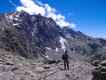
- But eventually we reached a shoulder where a huge face of broken rock and shale appeared. The Col de l'Aup Martin. We could see tiny figures on a vague traverse line rising up it, and some very steep looking zig zags above a short cliff near the top
- We started off across the shale. There were lots of small yellow crystaline rocks amongst the shale. Occasionally the path climbed down to cross small streams that had worn deep groove into the soft hillside
- At the end of the traverse the path passed underneath a small cliff, then started zig-zagging up the steeper final bit, following footsteps in the soft black shale, before arriving at the Col de l'Aup Martin. We sat in the sun on the windswept black top of the col, with incredible views of the long ridge of highly stratified rocky peaks hemming in the next valley
- The path traversed across more loose shale to the Pas de la Cavale. A sudden gust of wind had us crouching down hiding our faces half way across as we were showered with bits of shale and dust, but it disappeared as fast as it had come
- At the pass, there was some nice new red and white flashes on rocks, but they were for the variant GR, not the main route. In contrast, the obvious path didn't have any waymarks at all. I got out my ageing silva compass to check and found that the needle had fallen off!
- We chose the right path and took the long descent on hairpins, we could see the roof of the refuge quite soon after starting but it took almost 2 hours to get down to it. peering down we could see dozens of tight hairpins down the steep hillside below
- The refuge had an excellent menu, and we got a big bowl of spaghetti between us. Nearby camping was allowed in the grassy meadow above the refuge, so we pitched up, then I spent a fruitless half an hour crouched in the grass and the rocks trying to get some shots of the marmots
Refuge du Pre-de-la-Chaumette → La Chapelle-en-Valgaudemar
- We got going quite early, zig-zagging up the path, no waymarking, in the shade at first, still quite chilly. Once we got into the sun it warmed up a lot. After 90 mins we found a big shady boulder beside a small stream and sat down and made a pan of tea
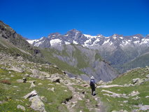
- Next the path picked its way up some easy rock slabs, and little red and white waymarking flashes re-appeared. Then the path got more rocky and gravelly, before arriving at the Col de valette. There were superb views across to Col de Gouiran which was about the same height, but we had to descend into a large grassy bowl and back up again to get there.
- From the col, the path descended in hairpins down more steep black schist. At Col de Gouiran there was a cold wind and everyone was sitting in the sun in front of some rocks for shelter
- It was hard to see where the next col was, the path traversed across a big hillside of steep schist slopes, worn into distinct fingers separated by water worn gullies. After a while the path zig-zagged up, to arrive at the exposed and windy Col de Vallonpierre, overlooked by the huge peak of Le Sirac
- Lots of people hanging around at the lake at Refuge de Vallonpierre, and we pushed on down the steep descent through scrubby rhododendrons with pink flowers, great views of snowy peaks ahead
- Long stretch along the valley bottom past the Refuge du Clot, where we stopped for a drink. This bit seemed to take quite a while and we arrived at Chapelle-en-Valgaudemar about 90 mins later than we expected. There were a choice of campsites, and the main one opposite the small supermarket was quite full but we managed to get a spot near the shower block
La Chapelle-en-Valgaudemar → Desert-en-Valjouffrey
- There was a bit of drizzle as we climbed towards Refuge Souffle, with increasingly heavier bursts. Every time I took my overtrousers off it would start up again. At souffles there was a large bunch of people just leaving, so we went in and had a huge jug of vegetable soup
- It was still raining when we left and we headed out into the cloud. The path traversed for a while, before crossing a patch of snow covered in sheep shit, then it climbed up steep zig-zags. The final bit climbed over rocky scree and boulder slopes. As the cloud cleared there were good views of steep cliffs all around.
- It was still cloudy when we reached the rocky top of Col de Vaurze. The descent started off down a steep slope of rocky boulders. Later on there were hairpins through grassy hillside with lots of good flowers
- We reached the small farming village of Desert. There was a gite which was packed out with a large french team that had arrived, and an auberge which did rooms on a demi-pension basis only. Instead we pushed on an camped a bit further up the hillside from the village. We has just got settled when there was an ominous noise from outside the tent, a mixture of a growl and a squeal. we listened intently for a while and could hear it fading off down the hillside.
Desert-en-Valjouffrey → Valsenestre
- We could see some blue sky when we get out of the tent, but there was some light cloud drifting down from the hill, and by the time we got going we couldn't see back down to the valley. We were looking for a tea stop place, but the stream was all dried up. Eventually it appeared again and we stopped to put a pan of tea on. A large group of french walkers went past
- We pushed on and the path turned to steep zig-zags that had been recently constructed. We still couldn't see the valley or the col through the cloud. Things got muddier and stickier before we appeared at Col de Cote Belle. No views either way
- We started descending and went through an interesting area of slate cliffs, with spikey rocks sticking out at all angles. Very steep zig-zags through forest, occasionally ducking under fallen trees, then over a section of steep crumbling black shale
- Came to a junction where the route continued off to the right to the Col de la Muzelle, we took the left down to the refuge at Valsenenstre. Wild camping is not allowed in this area, but the path to Valsenenstre passes a bivi area about 15 minutes from the junction
- Very comfortable refuge, superb food, very friendly. It sold a few provisions, so we stocked up on a few packets of cookies
Valsenestre → La Danchere
- We got going quite early, breakfast at 7am, and on the move by 7:15. The route headed up to The Col de la Muzelle, considered by most books as the crux of the GR54. It didn't take that long to get to the bottom of it, where we could see that it was covered with a light dusting of snow. There were two rangers at the bottom doing a wild goat count, and they seemed concerned that I was wearing approach shoes, and warned us that the pass was quite dangerous.
- We got going, the path went up black shale and mud, the snow had made it wet and slippery. At first there were little chunks of shale sticking out of the mud which made good footholds, but then it got more muddy and we needed a bit of momentum to get over some bits. We could hear snow cracking and occasional rocks falling down over at the left hand side side of the climb. Eventually we got to some big boulders, and a rocky scree slope with a coating of snow, which was easier. We popped out at the top at about 11:30, and superb views appeared of the slopes down to Lac de la Muzelle.
- Got a cup of tea at refuge de la Muzelle, then climbed up to the Col du Vallon. It was lovely and sunny by this time, and we sat on the col and ate cookies in the sun.
- The descent down to Lac Lauvitel wasn't quite the doddle we expected, it went on for ages, there was lots of clambering down slabs, and there was a slightly exposed traverse to cross a gully nearer the lake. There was huge excitement as Jill spotted an Edelweiss growing just at the side of the path. At the lake we had the spectacle of tourists feeding the marmots so they could get photographs next to them. We stopped for cookies and dried bananas
- From the lake the path went through an interesting area of huge jumbled boulders, then descended towards Danchere. It seemed to take ages to get down and it was 6:30pm by the time we reached the Danchere turnoff. Jill was all for pushing on for another two and a half hours along the valley to Bourg D'Oisans, but I talked her out of it, and we wandered down into the small village of Danchere. There was an excellent gite, with old mountaineering pictures covering all the walls, and panoramic views from the dining room. We cooked up pasta on the terrace outside.
La Danchere → Bourg d'Oisan
- Short day, not much left to do, we wandered along the mossy path through the forest, past a waterfall. There was lots of construction work at one point, where they were building new flood defences by the river. The shopping street in Bourg d'Oisan was full of stalls and there were lots of cyclists everywhere
- The campsite opposite the supermarket looked really packed out, but there was another section that still had plenty of space. Spent the rest of the day eating and shopping in the town.